
What started out as a cool idea soon became a brutal but beautiful challenge, something we’ve unconsciously expected.
It all started during the latter half of 2016 when my older brother, a frequent Comrades marathon runner, convinced me, the never before marathon runner, to do my first ever marathon. We headed up and down Sani Pass under the banner of the event called Sani Stagger presented by Running Man Adventures. 42 Kilometers of slogging and 1300 meters of vertical ascent later and my first ever marathon was under the belt. A few weeks went by for me to recoup on my sense of humor and the subsequent ever so enthusiastic question popped up; What’s next?
What was next, seemingly a cool idea when you have your sense of humor back on track, was to be the toughest one-day run I can remember myself doing, the Num-Num Trail Challenge presented by Wildtrail Adventures.
What is the Num-Num Trail Challenge?
Be prepared, when you tell most people of your plan to do the Num-Num, you’ll be asked, “the what?”. I’ve had time to tailor the answer to this question to perfection and advise to keep it simple by saying “It’s a 32 kilometer run on a 5-day hiking trail route, somewhere between Machadodorp and Badplaas”. If you want to create confusion, use eNtokozweni and eManzana instead.

That tailored answer will be met with responses such as “oh OK”, which effectively means someone has no clue what you just said, the hamster taking a nap from running on the metaphorical wheel. Others will respond with “only 32 kilometers?”, which is quite frankly an internal brain stimulating question for the average Joe thinking “it’s like six Parkruns, a real walk in the park”. I have, to date, not completed a Parkrun so the average Joe might quite frankly be right, but trust me, you don’t want to come to the Num-Num under the impression that it is going to be a walk in the park. A walk, yes, and lots thereof, but this park will derail your mind and quite possibly some of your body parts from the norm.
Back to the Num-Num Trail Challenge, it’s a 32 kilometer one-day trail running event in the Skurweberge between Machadodorp and Badplaas. The trail is rocky and contains some huge boulders that you’d expect to find at the beach, some 1800 meters above where they belong. It takes a great deal of slogging, power hiking and mental strength, but at the end of the day your exhaustion will be overwhelmed by the sense of achievement. If you consider stepping into the world of trail running, the Num-Num certainly needs to be on your bucket list.
The route, my story and what to expect from the Num-Num
If you’re a trail noob you will hit your head against a branch at least once, or a gazillion times, but on the flip side there is multiple unstable bridges that you can use to get over it. Make peace with the trees and rather focus on the other uncontrollable elements.
With a distance of 32 kilometers at an altitude of between 1350 and 1810 meters above sea level and a total vertical ascent of approximately 1700 meters, one would expect to encounter lots of climbing and descending. That would be the correct assumption. If you haven’t had a chance to look at the elevation graph and simply think in terms of distance and speed, you will be humbled by most races that packs a bit of a challenge and the Num-Num is no different.
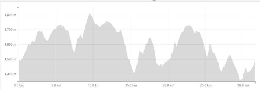
From my limited armor of this being my first proper trail run, I would rate the climbs as not being exceptionally long, but they sure pack a punch in terms of steepness. That said, not exceptionally long compared to what can be found in the Drakensberg. Taking on this challenge while thinking in the back of your mind that it’s a “run” would be close to suicide. Expect a technical trail sprinkled with rocks, boulders, unstable bridges, steps and annoying step ladders purposely built to not fit anyone’s stride length.
The route starts with a tiny bit of road running, about 100 meters or so. It’s really only a tiny stretch so you shouldn’t have enough time to think up questions like “Is this a road race?”. If you do, well then you should quite frankly be running faster. You’ll turn right and head upwards on a single pathway, not unnecessary steep or technical but enough to bump up the body temperature a few degrees, turning the majority of the field into a jacket shedding war zone. An extra jacket to carry would’ve annoyed me to death, so I opted for the compulsory wind jacket rolled up and tucked away along with the other necessities. A ever so slightly dip settles the nerves and lets you settle into your running rhythm before getting into the first set of tree lines. To summarize and as a rule of thumb, when you’re unable to see the sky, it’s usually steep. Making your way through these tree lines requires a bit of concentration. You can either focus on the ground and knock your head against branches, or feel free to sprain your ankle but save your head. I opted for the first option and lost some brain cells in the process. From here you do a bit of contour running, a technical switchback drop and some more contour running before reaching the top of the mountain scattered with boulders and sand. It’s a remarkable scene and mind boggling to be honest. Running and climbing though these huge stones on sand at some 1800 meters above sea level, strangely enough, felt pretty close to running on a beach. Water point 1 comes at just the right time to take this all in.

After the first water point the route goes downwards quite fast, it’s rocky but not really that loose. When you’re comfortable rolling down a mountain you’ll feel at home here, just tuck your feet in and roll along. Jokes aside, it’s run able, but keep your concentration levels up there. The next treeline section awaits which turns you going upwards again, out of the tree lines and towards the highest point of the route at an altitude of just over 1800 meters. With just about 10 kilometers done and dusted at this point, you’ll be able to turn the screw and burn a bit of matches for the next 2 kilometers before stacking up on some more matches when you reach water point 2 at roughly the 11.5 kilometer mark.
“Don’t eat something that you’ve never trained with” is a great tip among athletes, and with good reason, but man you’ll feel bleak and dull when miss out on the snacks at the water tables. This is not a cycling race, enjoy the breather, drop your heart rate and hammer the food table. Now there’s a lot of hype and science on what to eat and where to eat, however, when you’ve knocked your head against branches a gazillion times you tend to forget these things. Stick to your plan. As a rule of thumb, I try to take in as much as possible from my tried and tested food artillery without feeling uncomfortable. I tend to be biased towards solid stuff and real food as opposed to gels and plastic but that comes down to personal preference. Staying hydrated and topped up throughout, are to me, the most important factors.

Leaving the second water table you’ll be able to turn on the screw again, running slightly downhill on the contour line. This part blew me away and I remember a little prayer going up at this point. You can basically see your playground for the next 10 kilometers from here. Throw into the mix a few wildebeest if you’re lucky and shoot down the mountain to your right at approximately 13.5 kilometers in. At this stage you’ll be used to running downhill, jumping rocks, dodging branches and navigating the obstacles. Concentration remains key. It was here where I had a head on collision with a branch, I was shaken and stirred and felt a bit drunk afterwards. Next moment, as I approached the bottom half of the descent there was quite a steep drop to the left and I remember thinking you’d fall quite hard if you go down there and “boom”, I stumbled over a rock and my heart was pumping in my mouth. The martini feeling returned.
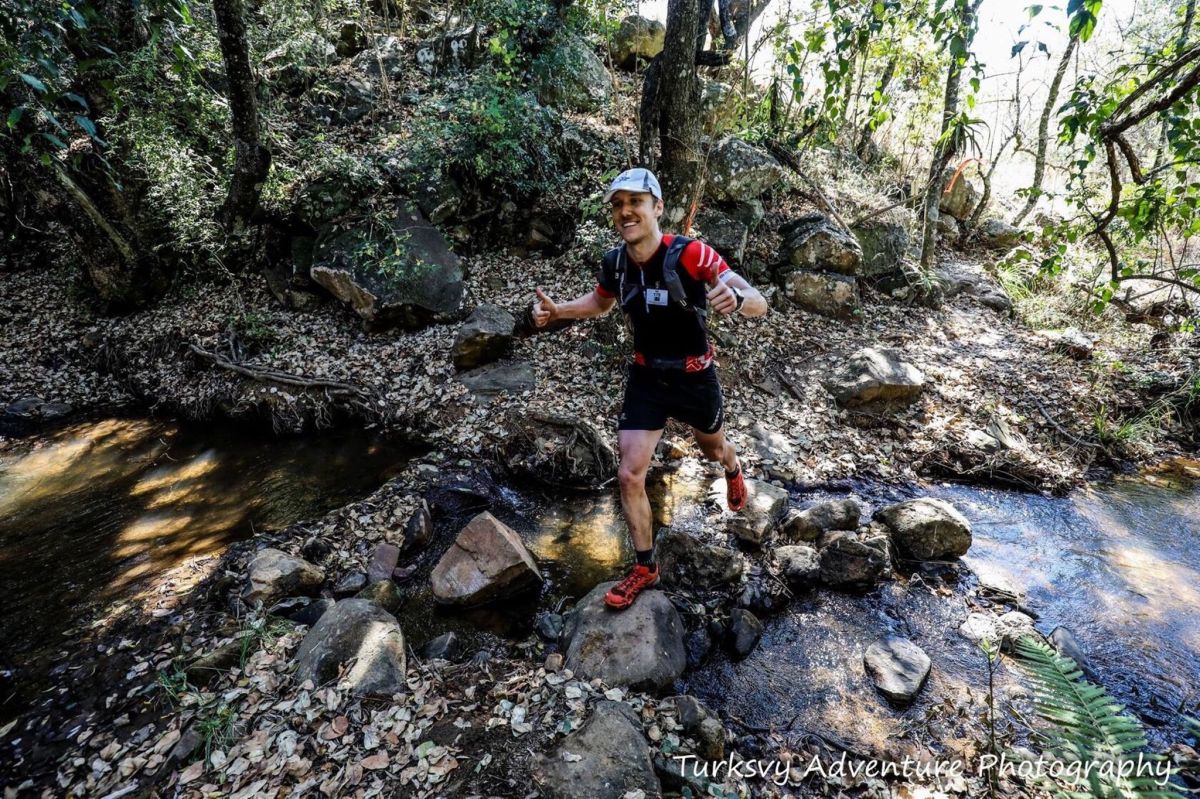
Reset the mind in order to cross an off-camber not so stable bridge at the bottom. As a top tip when you reach this bridge too early it will still be wet and super slippery, so by all means rather spend extra time at water point 1 and 2.
Next moment you’ll twist your way up a pretty damn steep section through the tree lines. It is properly steep and to cap it off some of the bushes have sharp thorns so I’m pretty sure you’ll have some tweezering to do after the event. Fast forward from here where you’ll be finding some smiles at water point 3 just over the crest of this climb. I refilled my water at this stage not knowing how tough the waterfall climb will be and how long it will take. In hindsight I could’ve done the climb a bit lighter, but I’d rather carry some weight and have a hydration buffer to be honest. If I ran out of water I’d use every opportunity to refill.
Next up is a beautiful waterfall where you’ll meet your friend gravitation. When you see the water falling down all the way from the top, just remember that you’ll have to fight that gravitation all the way up there. Thank me later for planting this miserable thought into your head, and by all means have a little smile before starting this ascent, it will lift your spirit. Water point 4 is right at the top and they purposely make you climb some stairs into the little wooden hut to make the food just a little more satisfying, or to get a good laugh, one or the other. I opted for some jelly babies here as I thought they’d pair nicely with my jelly legs. I probably should’ve have eaten an army of them as for the next few minutes they were marching in typical South African fashion in my stomach. They soon got lazy and went for lunch. I was glad, and lucky.

I knew from here on onwards would be mostly downhill with a few kicks to ramp up some cramps. As a novice in the running world I don’t necessarily like downhill running due to the increased hammering on the legs, but at least the kilometers ticks by faster. The next part included a little concrete path section and, as expected, mostly downhill running with a few kicks up to the point where you can see the race village just below. The key here is not to be pulled into mind games with yourself to even think you want to go there, it’s only a short little loop left, like a Parkrun of some sort, I guess. Rewind a few steps, water point 5, next to the tar road and just before the last little park run of about 5 kilometers. At least when reaching water point 5 you can’t see the race village anymore and your thought of quitting disappears, I hope.
I had to play the last little bit down as a Parkrun to make you go past the point of no return, but quite frankly it’s not. The last little loop goes out towards to north-eastern side of the race village where you go face to face with yet another climb which leads you to a cool chain ladder and a magnificent piece of downhill switchbacks. Down into the tree lines to finish off the magnificent route along a water stream for the last few kilometers. Unfortunately, you’ll be running uphill along this stream but thank me later for not detailing the final sting in the tail along these tree lines but when you’ve reached this point you’ll be on autopilot anyway. Focus on the end.
The race village comes rather unexpected as you can’t see it until the final 200 meters or so and the fact that there was no real banner came as a bit of a surprize, but the joy of the trail and the challenge lay behind us and it felt good, really good.
Best wishes and good luck,
Louis
Photo credits to: Turksvy Adventure Photography
